የድሮን ቅየሳ ትክክለኛነት፡ GCPs፣ PPK እና ከ5 ሳ.ሜ በታች የትክክለኛነት ማብራሪያ
ያለ ምንም ማስተካከያ፣ ተራ የድሮን በረራ ልክ እንደ ስማርት ስልክዎ ጂፒኤስ ከትክክለኛው ቦታ በብዙ ሜትሮች ሊዛባ ይችላል። ይህንን ጥሬ መረጃ ወደ ጥቂት ሴንቲሜትር የምህንድስና ደረጃ ትክክለኛነት የሚቀይሩት ሁለት ቴክኖሎጂዎች ናቸው፡ የመሬት መቆጣጠሪያ ነጥቦች (GCPs) እና የPPK (Post-Processed Kinematic) ማስተካከያ። ከዚህ በታች ባለው ሲሙሌሽን ውስጥ እንዴት እንደሚሰሩ በቀጥታ ይመልከቱ።
የመሬት መቆጣጠሪያ ነጥቦች አጠቃላይ የበረራ መረጃውን በመሬት ላይ በDGPS በትክክል ከተለኩ መጋጠሚያዎች ጋር ያገናኛሉ። የPPK ማስተካከያ ደግሞ ከበረራ በኋላ የሳተላይት ቤዝ ጣቢያ መረጃን በመጠቀም የድሮኑን የበረራ ምዝግብ ማስታወሻ ያጠራል። ሁለቱ ተጣምረው የግንባታ ቡድኖች እና የመሬት አስተዳደር ሙሉ በሙሉ ሊተማመኑበት የሚችሉትን አስተማማኝ ውጤት ያመጣሉ።
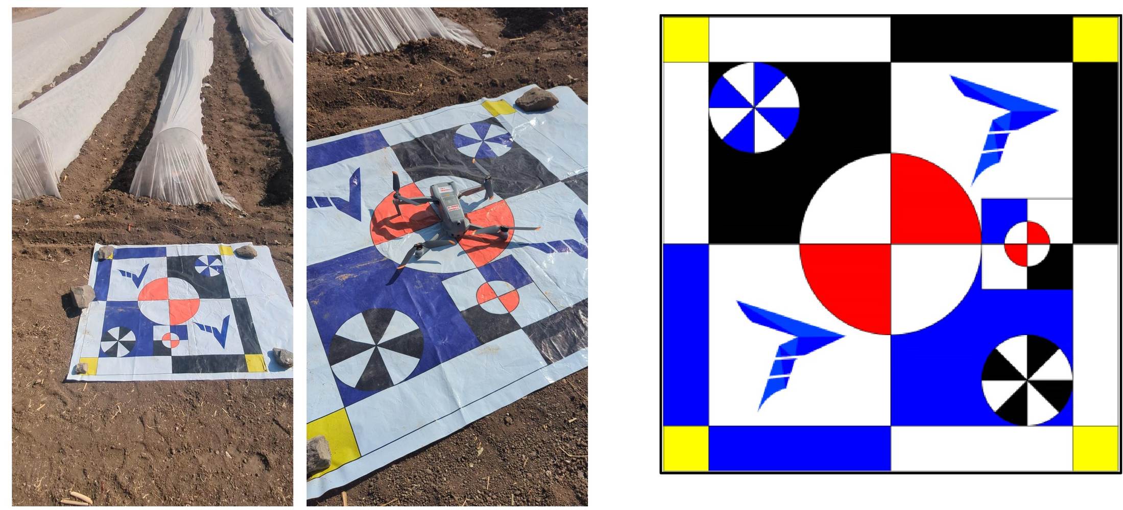
የድሮን በረራ ከመሬት መቆጣጠሪያ ነጥቦች ጋር እንዴት እንደሚቆለፍ ይመልከቱ
የበረራ መስመር እና የመሬት መቆጣጠሪያ ነጥብ አኒሜሽን
እራስዎ ይሞክሩት፡ የPPK ማስተካከያን በቀጥታ ለማየት ስላይደሩን ያንቀሳቅሱ
የነጥቦች ደመና (Point Cloud) ማስተካከያ ሲሙሌተር
ሁለቱም ቴክኖሎጂዎች ለምን በአንድ ላይ እንደሚያስፈልጉ
| ቴክኖሎጂ | ምን እንደሚያስተካክል | የሚገኘው ውጤት |
|---|---|---|
| የመሬት መቆጣጠሪያ ነጥቦች (GCPs) | አጠቃላይ ዳታውን በDGPS ከተለኩ መጋጠሚያዎች ጋር ያገናኛል | በሳይቱ ዙሪያ ያለውን ስልታዊ የቦታ መዛባት ያስወግዳል |
| የPPK ማስተካከያ (ድህረ-ሂደት) | የቤዝ ጣቢያ መረጃን በመጠቀም የድሮኑን መጋጠሚያዎች ያጠራል | ያለ ብዙ GCPs የእያንዳንዱን ነጥብ ትክክለኛነት ያሳድጋል |
| የሁለቱ ቅንጅት | ፍጹም የመሬት ትስስር + የነጥብ ደረጃ ትክክለኛነት | በታቀዱ በረራዎች ላይ ከ5 ሳ.ሜ በታች (Sub-5cm) ትክክለኛነትን ያረጋግጣል |
የPPK ማስተካከያ በትላልቅ ሳይቶች ላይ የሚያስፈልጉትን የGCP ነጥቦች ቁጥር ሊቀንስ ይችላል። ሆኖም ግን ለህጋዊ የድንበር ስራዎች የGCPs አስፈላጊነት ሙሉ በሙሉ ሊቀር አይችልም።
ጥሬ የድሮን መረጃ በዓይን ሲታይ ግልጽ ሊመስል ይችላል፣ ነገር ግን በመሬት ላይ ያለ መነሻ ነጥብ ትክክለኛ ቦታውን እስካላረጋገጠ ድረስ አስተማማኝ አይደለም።
ይህ ለፕሮጀክትዎ ምን ትርጉም አለው
ፕሮጀክትዎ በህግ እና በምህንድስና ተቀባይነት ያለው የድንበር መረጃ የሚፈልግ ከሆነ የGCP ጥግግት እና የPPK ማስተካከያ መኖሩን ሳያረጋግጡ የድሮን መረጃ አይቀበሉ። የእኛ የድሮን ቅየሳ ሂደት ይህንን መስፈርት በጥብቅ የሚከተል ሲሆን እያንዳንዱ መረጃ ከመሬት ቶፖግራፊ (Topography) ጋር ይጣራል።
በሚያምር ሁኔታ የተዘጋጀ ኦርቶሞዛይክ ካርታ ብቻውን ትክክለኛነትን አያረጋግጥም። ሁልጊዜ በገለልተኛ መቆጣጠሪያ ነጥቦች (Checkpoints) የተረጋገጠ የትክክለኛነት ሪፖርት ይጠይቁ።
የተረጋገጠ የምህንድስና ደረጃ ትክክለኛነት ያለው የቅየሳ መረጃ ይፈልጋሉ?
የድሮን ቅየሳ ድርጅት ከመምረጥዎ በፊት ከእኛ የናሙና ትክክለኛነት ሪፖርት ይጠይቁ።
ተደጋግመው የሚጠየቁ ጥያቄዎች (FAQ)
GCP የድሮን የአየር ላይ ፎቶዎችን ከእውነተኛው የምድር መጋጠሚያዎች ጋር ለማገናኘት በDGPS መሬት ላይ በትክክል የሚለካ መነሻ ምልክት ነው።
PPK ማለት Post-Processed Kinematic ሲሆን፣ ከበረራ በኋላ የቤዝ ጣቢያ መረጃን በመጠቀም የድሮኑን ጂፒኤስ ዳታ የሚያስተካክል ዘዴ ነው።
ያለ GCPs ጥሬ የድሮን ጂፒኤስ ከ2 እስከ 5 ሜትር ሊዛባ ይችላል፣ ይህም ለምህንድስና ስራዎች ተስማሚ አይደለም።
PPK የሚያስፈልጉትን የGCPs ብዛት ይቀንሳል፣ ነገር ግን ለመጨረሻ ማረጋገጫ ጥቂት GCPs ሁልጊዜ አስፈላጊ ናቸው።
ለመደበኛ መካከለኛ ሳይት ከ4 እስከ 6 በደንብ የተከፋፈሉ GCPs በቂ ናቸው።
በትክክለኛ GCP እና PPK አማካኝነት ከ5 ሳ.ሜ በታች (Sub-5cm) ትክክለኛነት በቀላሉ ማግኘት ይቻላል።
የተጠናቀቀውን ካርታ ብቻ ከማየት ይልቅ በገለልተኛ መቆጣጠሪያ ነጥቦች (Checkpoints) ላይ ያለውን ልዩነት የሚያሳይ ሪፖርት ይጠይቁ።
አዎ፣ GCPs በሳይቱ ማዕዘኖች፣ ጠርዞች እና መሃል ላይ በእኩል መሰራጨት አለባቸው።
ሁለቱም የቤዝ ጣቢያ መረጃን ይጠቀማሉ፣ ነገር ግን RTK በበረራ ወቅት በቀጥታ ይሰራል፣ PPK ደግሞ ከበረራ በኋላ በቢሮ ውስጥ ይሰራል
GCPsን መተው የመስክ ጊዜን እና ወጪን ይቆጥባል፣ ነገር ግን ትክክለኛነትን በእጅጉ ይቀንሳል።
ይህ መስመር ለፕሮጀክት ጥያቄዎች ብቻ የተመደበ ነው።