How DGPS Works and Why It is the Backbone of Railway Topography Surveys in India
If you have ever wondered how survey teams produce those precise topographic drawings of railway stations, complete with track alignments, utility lines, platform edges, and level data accurate to a centimeter, the answer almost always comes back to one technology: DGPS.
This article breaks down how DGPS works, what it actually delivers on a railway topography project, and why it has become the go-to method for serious infrastructure survey work across India.
What is DGPS and How is it Different from Regular GPS?
Your phone's GPS is accurate to about 3 to 5 meters on a good day. That is fine for navigation. It is completely useless for engineering survey work where a 10 cm error can mean a design clash, a wrong level, or a misaligned track.
DGPS (Differential GPS) solves this by using two receivers working together:
- Base Station: A receiver placed at a known, fixed coordinate. It continuously calculates the difference between its known position and what the GPS satellites are reporting. This difference is the "error" introduced by atmospheric interference, satellite geometry, and signal drift.
- Rover: The field receiver carried by the survey crew. It receives the real-time error correction from the base station and applies it to every position it records.
The result is positional accuracy of 1 to 3 centimeters in real time, every time the rover records a point. RTK (Real Time Kinematic) is the modern, faster version of this same principle, using carrier-phase measurements for even tighter accuracy.
Think of it this way: the base station is like a trusted friend standing at a known landmark, constantly telling you exactly how far off the street signs are. With that information, you can navigate to millimeter precision even when the signs themselves are slightly wrong.
Why Railway Topography Surveys Demand This Level of Accuracy
A railway station is one of the most complex survey environments you will encounter. Within a single site, you have:
What Needs to be Captured
- Multiple rail tracks at varying levels
- Platform edges and heights
- Overhead equipment structures
- Underground utilities (cable ducts, drainage)
- Station buildings and boundary walls
- Road approaches and level crossings
- Benchmarks and existing survey marks
Why Accuracy Matters Here
- Track geometry design requires mm-level level data
- Platform height affects passenger safety
- Utility conflicts cost crores to fix post-construction
- Alignment errors carry forward into structural design
- Indian Railways specifications are strict
- Multiple agencies use the same base drawing
- Errors discovered late mean complete resurvey
A 5 cm error in platform edge level or track alignment is not just a survey problem. It cascades into civil design, structural drawings, and ultimately into construction. Getting it right at the survey stage is always cheaper than fixing it later.
How a DGPS Railway Topography Survey Actually Works on Site
Here is what a typical DGPS topographic survey looks like at a railway station, from mobilization to final drawing delivery:
Step 1: Control Network Establishment
Before any detail survey begins, the team establishes a network of Ground Control Points (GCPs) across the station area. These are permanent marks whose coordinates are precisely fixed by DGPS observations. Every subsequent measurement references back to this network, ensuring all data is in a consistent coordinate system.
Step 2: Benchmark Leveling
The survey team ties into the nearest benchmark of the Indian Railways level datum. DGPS gives horizontal accuracy easily, but for precise vertical (height) data on a railway project, we confirm elevations through differential leveling with a digital level instrument. Both datasets are then merged.
Step 3: Detail Survey with RTK Rover
With the base station running, the rover operator moves across the site capturing every feature. Each point is recorded with its X, Y, and Z coordinates in real time. On a typical railway station of 500m to 1km length, this phase captures 2,000 to 5,000+ individual points covering:
- Rail top levels at regular intervals (every 10 to 25m)
- Track center lines and gauge measurements
- Platform edges, ramps, and surface levels
- Drainage channels, manholes, and invert levels
- Overhead structure footings and column positions
- All visible utilities above ground
- Building footprints and boundary features
Step 4: Topographic Drawing Preparation
All field data is processed and drafted into an AutoCAD topographic drawing with contour lines at the specified interval (typically 0.25m or 0.5m for railway sites), all captured features labeled, and a coordinate grid overlay. The drawing becomes the base document for all subsequent engineering design.
Sample Topographic Drawing: What the Output Looks Like
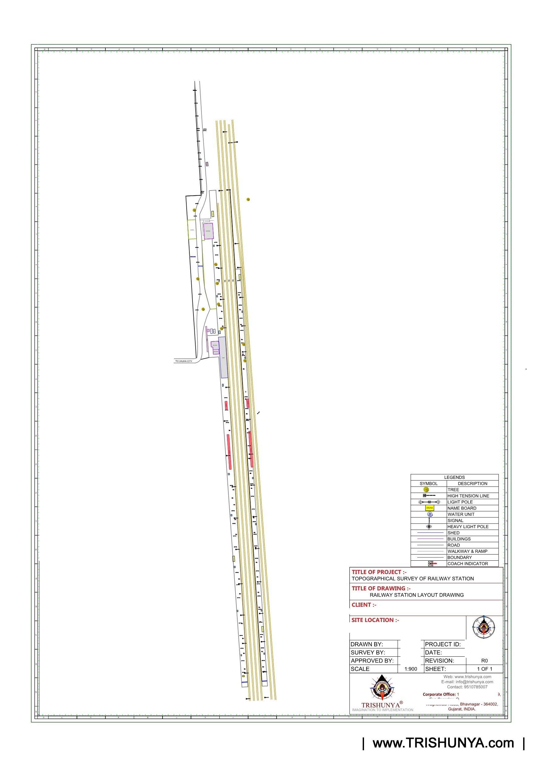
Sample topographic drawing from a railway station survey showing track alignments, platform edges, contour levels, and utility positions. All coordinates referenced to Indian coordinate system.
Key Deliverables from a Railway Topography Survey
| Deliverable | What it Shows | Who Uses It |
|---|---|---|
| Topographic Drawing (DWG) | All ground features, levels, contours, track positions | Civil engineer, architect, structural designer |
| Rail Track Alignment Sheet | Track center lines, curves, gradients, chainage | Track design team, permanent way engineer |
| L/S and Cross-Section Sheets | Longitudinal profile and cross-sections at intervals | Earthwork design, platform height design |
| Utility Capture Drawing | Position and depth of visible underground utilities | Services coordination, clash detection |
| Benchmark and GCP Report | Coordinates and levels of all control points | Future surveys, design verification |
| Feature Geo-Tagged File (KMZ/SHP) | All features with GPS coordinates for GIS use | GIS team, project monitoring |
Site in Action: Our Team at Work
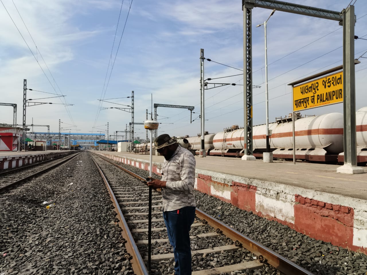
Trishunya team on site conducting DGPS-based topographic survey. Base station visible in background; rover operator capturing rail track levels and platform geometry.
Watch Our Team in the Field
Short clips from our actual survey work - DGPS and topographic surveys across different project types:
Common Mistakes in Railway Topography Surveys (and How We Avoid Them)
Not every survey team gets this right. Here are the problems we see most often when clients come to us after a failed first survey:
Using handheld GPS for detail survey
3 to 5 meter accuracy. Completely unusable for railway engineering. We see this on small contractor surveys regularly.
No independent benchmark check
DGPS vertical accuracy needs confirmation via differential leveling on railway sites. Skipping this step creates level errors that show up during construction.
Sparse point capture in critical zones
Platform edges, track transitions, and level crossings need dense point capture. Under-surveying these areas leads to incorrect cross-sections and design errors.
What Trishunya does differently
Every railway topography survey includes: dual-frequency DGPS, independent benchmark verification, minimum point density specifications per zone, and a QC check before drawing delivery. No shortcuts.
How Long Does a Railway Station Topography Survey Take?
This is always one of the first questions from project managers. Here is a realistic timeline based on our experience:
| Station Size | Field Work | Processing and Drawing | Total Delivery |
|---|---|---|---|
| Small (up to 500m) | 1 to 2 days | 2 to 3 days | 4 to 5 days |
| Medium (500m to 1.5km) | 2 to 4 days | 3 to 4 days | 6 to 8 days |
| Large (1.5km and above) | 4 to 7 days | 4 to 6 days | 8 to 13 days |
Timeline can be compressed for urgent projects. We have mobilized within 48 hours and delivered final drawings in 5 days for time-critical tenders. Talk to us if you are working on a tight deadline.
Who Needs This and When
If you are working on any of the following, a proper DGPS topography survey is not optional. It is the foundation everything else is built on:
- New railway station design or redevelopment
- Platform extension or new platform construction
- Gauge conversion projects
- Third or fourth line addition between existing stations
- Station area drainage improvement
- Foot over bridge (FOB) or subway design
- Electrification mast foundation design
- Railway land boundary demarcation
Every one of these project types starts with the same question from the design team: "Where is the base survey?" If you don't have a proper DGPS topographic drawing, you cannot start design. And if you start design without one, you will regret it later.
Why Clients Choose Trishunya for Railway Survey Work
We have worked on railway topography surveys across Gujarat, Rajasthan, Maharashtra, and other states for EPC contractors, consultants, and Indian Railways divisions. Here is what clients tell us after working with us:
±2cm
Horizontal accuracy delivered on railway projects using dual-frequency DGPS with network RTK
48 hrs
Fastest mobilization to site from enquiry confirmation for urgent railway survey projects
PAN India
Survey coverage across India. Equipment and experienced teams available for deployment anywhere
DWG + GIS
Deliverables in AutoCAD DWG, KMZ, and Shapefile formats compatible with all design platforms
Ready to Start Your Railway Survey?
Whether you are a project manager at an EPC contractor, a consultant preparing a DPR, or a developer planning infrastructure near a railway station, we can help you get the survey data you need quickly and accurately.
Send us your project location, approximate extent of survey area, and required deliverables on WhatsApp. We will send you a quotation the same day.
Get a Same-Day Quote on WhatsApp
Back to all articles