How to Read and Verify Your 7/12 Extract Against a Land Survey
A 7/12 extract can say one thing. The ground can say another. We have seen buyers walk away from registration counters because the area on the Satbara did not match what a total station measured on site, and by then the earnest money was already gone.
The 7/12 extract, also called Satbara Utara, is the revenue record maintained under the Maharashtra Land Revenue Code for every agricultural and non-agricultural parcel. It lists the survey number, owner names, area, land use, and any pending mutations. It is not, by itself, proof that the boundaries on paper match the boundaries on the ground. That gap between the revenue record and the physical plot is exactly where a land survey earns its cost.
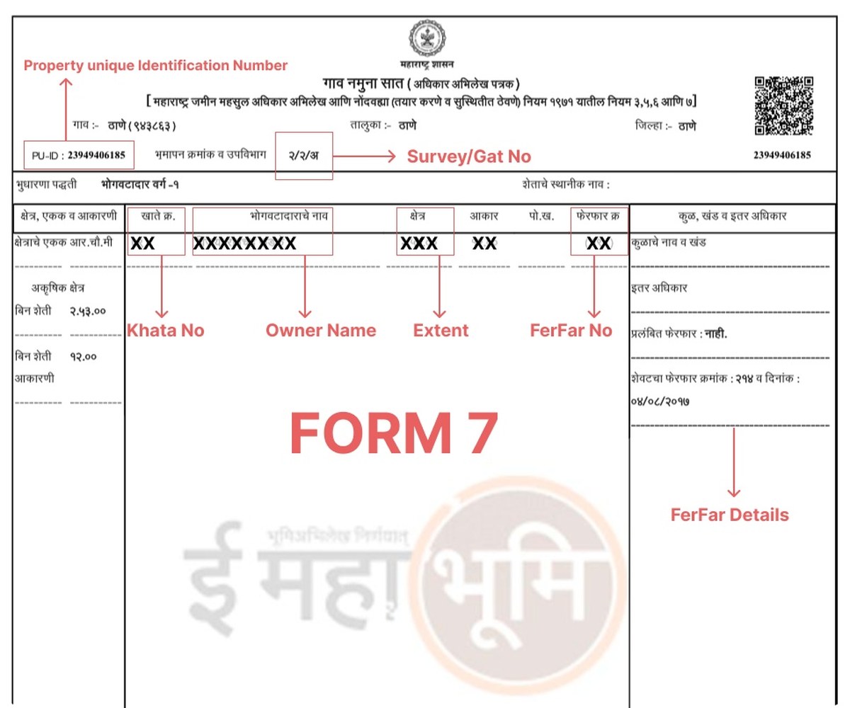
What the 7/12 Extract Actually Tells You
Before you compare anything, know what each column means. A 7/12 extract is read top to bottom, and three columns matter most for a land survey cross-check: the survey/gat number, the area in hectares or acres, and column 12, which flags pending mutations. A digitally signed extract downloaded from the state's land record portal (Mahabhulekh in Maharashtra, AnyRoR in Gujarat, Bhulekh equivalents elsewhere) is legally valid for registration and loan purposes, but it only reflects what was last surveyed and entered, sometimes decades ago.
Why the 7/12 Area Can Differ From a Fresh Survey
Old revenue records were often prepared with chain and compass methods, sometimes over a century ago, and re-verified only when a mutation was filed. Field boundaries shift with fencing changes, road widening, informal encroachment, or simple measurement error carried forward through decades of copies. A modern DGPS or total station survey resurveys the actual corners and computes area from real coordinates, not from an inherited number.
A mismatch between the 7/12 area and a fresh survey does not automatically mean fraud. It usually means the record predates modern measurement. The fix is a resurvey and, where needed, a formal mutation entry, not panic.
Step-by-Step: Verifying Your 7/12 Against the Ground
Download the official extract
Pull the 7/12 directly from the state land record portal using district, taluka, village, and survey number. Never rely on a copy handed over by a seller or broker.
Note the recorded survey number and area
Write down the exact gat/survey number and the area in the units shown (hectares, acres, or guntha). This is your baseline.
Commission a physical land survey
A DGPS or total station survey locates the actual boundary pillars and corners and computes area from measured coordinates, not from the old paper record.
Overlay survey coordinates on the recorded boundary
Compare the resurveyed polygon against the 7/12 description and any available Bhu-Naksha map. Flag any corner that has shifted.
Check column 12 for pending mutations
Unresolved mutation entries mean ownership or area on the extract may still be under revision. Resolve these before relying on the number.
File a mutation if the survey confirms a genuine gap
If the resurvey shows a real, defensible difference, the correction gets filed with the revenue office so the 7/12 finally matches the ground.
7/12 Extract vs Physical Land Survey: Quick Comparison
| Aspect | 7/12 Extract | Physical Land Survey |
|---|---|---|
| What it shows | Recorded ownership, area, land use, mutations | Actual measured boundary, corners, and area |
| Basis | Historical revenue records, sometimes decades old | Fresh DGPS/total station coordinates |
| Legal status | Valid for registration when digitally signed | Supporting evidence; feeds mutation if area differs |
| Update frequency | Updated only on mutation filing | Reflects present-day ground conditions |
| Best used for | Ownership and title checks | Boundary, area, and encroachment verification |
Common Mismatches We See in the Field
Shrunk or expanded plots
Neighboring construction or informal fencing nudges a boundary a few feet at a time until the ground no longer matches the extract's stated area.
Survey number confusion
Adjacent parcels sometimes get the wrong survey number quoted in old sale deeds, especially after a parcel was subdivided.
Accurate corner coordinates
A resurvey pins every corner to a coordinate system, removing ambiguity from vague chain-and-rope descriptions.
Mutation-ready documentation
Survey reports formatted for revenue office submission speed up correcting the 7/12 once discrepancies are confirmed.
The 7/12 tells you what the record believes. A survey tells you what the ground actually holds. Buy on the second one.
When You Should Not Skip a Survey
Skipping the physical survey is tempting when the seller is in a hurry or the price looks fair. It is a mistake in three situations especially: when the plot borders agricultural land with informal fencing, when the 7/12 record has not been updated in over 10 years, and when the survey number on the sale deed does not clearly match what the seller is physically showing you. In each of these, a DGPS survey resolves the ambiguity before money changes hands, not after.
Never register a property purchase based solely on a 7/12 extract shown by the seller. Download it yourself from the official portal and cross-check the survey number against what you are physically standing on.
What a Professional Survey Adds to the Paper Trail
A field-verified survey report gives you coordinate-referenced corner points, a measured area figure, and a boundary overlay you can hand to a lawyer or the revenue office. Combined with topographic mapping of the site, it also flags drainage lines, slope, and access points that never show up on a revenue record at all. That combination is what turns "the paper looks fine" into "we checked the ground and it matches."
Buying land on a 7/12 extract alone?
A short DGPS boundary verification, before you sign, costs far less than a dispute after.
Frequently Asked Questions
It is the primary land revenue record in Maharashtra showing ownership, survey number, land area, land use, and mutation history for a specific parcel. It is used for property verification, loan applications, and registration.
No. It confirms ownership and recorded area but does not verify the actual physical boundary on the ground. A separate land survey is needed to confirm that the plot matches the record.
Older revenue records were often prepared with less precise chain and compass methods and may not reflect boundary shifts from fencing changes or road widening over the years. A modern DGPS survey measures the present-day boundary directly.
Use your state's official land record portal (Mahabhulekh for Maharashtra, AnyRoR for Gujarat, or the relevant Bhulekh portal elsewhere), select district, taluka, and village, then enter the survey number to download a digitally signed copy.
Column 12 lists pending mutation entries, meaning changes in ownership or area that are filed but not yet finalized. A pending mutation is a signal to investigate further before purchase.
Yes. A survey report with measured coordinates and area is the standard supporting document used when filing a mutation request with the revenue office to correct a discrepancy.
A DGPS survey typically achieves centimeter to sub-meter accuracy, compared to the far coarser tolerances of historical chain-and-compass surveys used to prepare many existing 7/12 records.
It is still recommended, especially for larger parcels or plots bordering agricultural land, since site plans can be outdated or drawn without a fresh field measurement.
Bring the 7/12 extract, the sale deed or agreement, any prior survey sketch or Bhu-Naksha map, and details of the survey number so the field team can locate the correct parcel.
For a standard residential or agricultural plot, field measurement and a verification report typically take a few days, depending on plot size, terrain, and access.
This line is reserved for project leads. Please do not contact for learning, training, or job inquiries.