GNSS RTK ተብራርቷል: የሴንቲሜትር ትክክለኛነት እንዴት እንደሚሰራ
መደበኛ የስማርትፎን GPS ጥቂት ሜትሮች ትክክለኛነት አለው፤ ይህም ለአሰሳ ጥሩ ቢሆንም ለቅኝት (surveying) ግን ጥቅም የለውም። RTK ወይም Real-Time Kinematic አቀማመጥ ሁለተኛ የተስተካከለ ተቀባይ በመጠቀም ስህተቶችን በቅጽበት በማረም ያንን ትክክለኛነት ወደ ሴንቲሜትር ዝቅ ያደርገዋል።
ምስጢሩ ምልክቶችን ማወዳደር ነው። በትክክል በሚታወቅ ቦታ ላይ የተቀመጠ ቤዝ ጣቢያ (base station) ከተንቀሳቃሽ ሮቨር (rover) ጋር ተመሳሳይ የሳተላይት ምልክቶችን ይቀበላል፣ በእነዚያ ምልክቶች ላይ ያለውን ስህተት ያሰላል፣ እና ሮቨሩ ወዲያውኑ የሚተገብረውን እርማት ያሰራጫል።
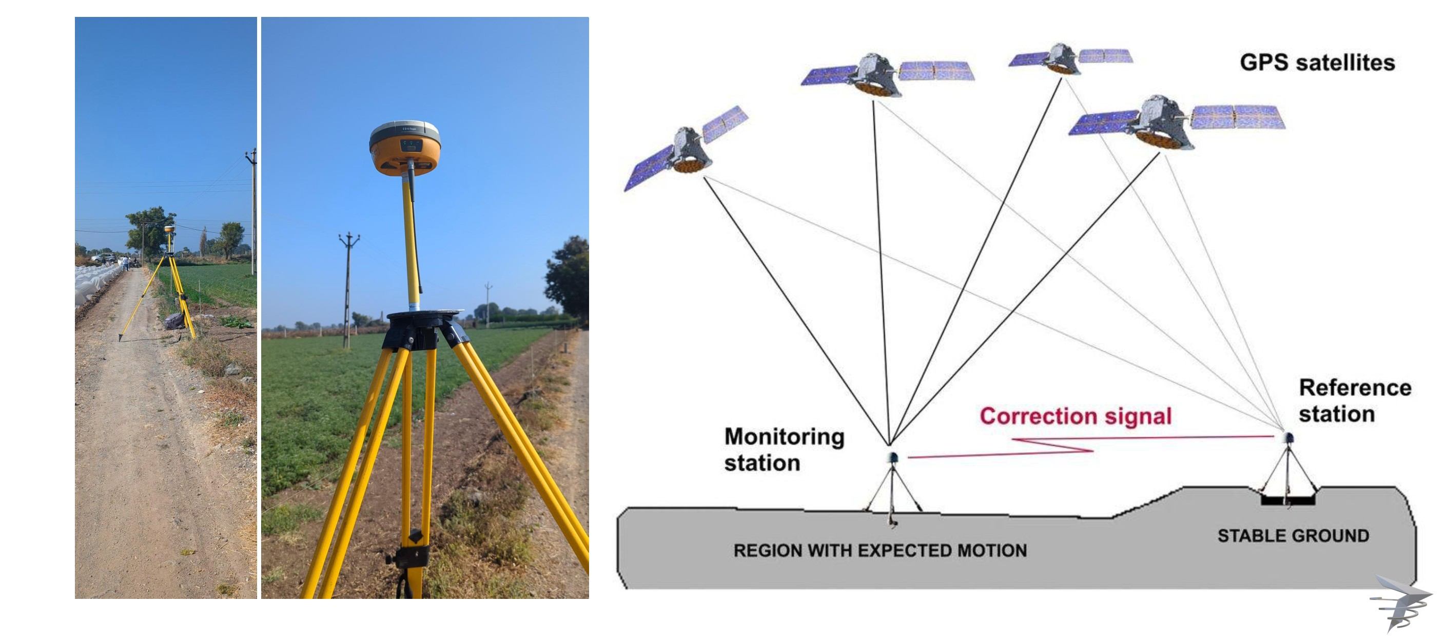
የRTK እርማት በተግባር ሲሰራ ይመልከቱ
የቀጥታ እርማት ስርጭት ማስመሰያ (Simulation)
ርቀት በትክክለኛነት ላይ እንዴት ተጽዕኖ እንደሚያሳድር ይመልከቱ
በተግባር የሚሞከር የቤዝላይን ርቀት መመርመሪያ
Fixed እና Float መፍትሄዎችን ይሞክሩ
አቀማመጥን ለመመዝገብ ጠቅ ያድርጉ
የRTK አቀማመጥ እንዴት እንደሚሰራ
የቤዝ ጣቢያ ዝግጅት
ተቀባይ በትክክል በሚታወቅ ኮኦርዲኔት ላይ ይቀመጣል፤ ይህም የተቀኘ ወይም ከሚታወቅ ቤንችማርክ ጋር የተያያዘ ነው።
የሳተላይት ምልክት መቀበል
ሁለቱም ቤዝ እና ሮቨር ከተመሳሳይ የGNSS ሳተላይቶች ስብስብ በአንድ ጊዜ ምልክቶችን ይቀበላሉ።
እርማትን ማስላት
ቤዝ ጣቢያው ያለበትን የታወቀ ቦታ ከሳተላይት ምልክቶች ከተሰላው ቦታ ጋር በማወዳደር የወቅቱን ስህተት ይወስናል።
እርማቱን ማሰራጨት
ቤዝ ጣቢያው ይህንን የእርማት መረጃ በሬዲዮ ግንኙነት ወይም በኢንተርኔት በኩል ለሮቨሩ በቅጽበት ይልካል።
Fixed መፍትሄ ማግኘት
ሮቨሩ እርማቱን በመተግበር የሴንቲሜትር ትክክለኛነት ያለው የተረጋጋ (Fixed) አቀማመጥ ለማግኘት ብዥታዎችን ይፈታል።
የተረጋጋ (Fixed) RTK መፍትሄ የሴንቲሜትር ትክክለኛነትን ይሰጣል፤ ነገር ግን ሲስተሙ የሲግናል ብዥታዎችን ሙሉ በሙሉ መፍታት በማይችልበት ጊዜ የሚከሰተው Float መፍትሄ የዴሲሜትር ደረጃ ትክክለኛነትን ብቻ ሊሰጥ ይችላል። የቅኝት ነጥቦችን ከመመዝገብዎ በፊት ሁልጊዜ የFixed ሁኔታን ያረጋግጡ።
GPS በግምት የት እንዳሉ ይነግርዎታል። RTK ግን እስከ ጥቂት ሴንቲሜትሮች ድረስ በትክክል የት እንዳሉ ይነግርዎታል።
RTK ለቅኝት ስራ (Surveying) ለምን አስፈላጊ እንደሆነ
ከወሰን ማዕዘኖች እስከ ግንባታ ምልክታ (stakeout) ድረስ እያንዳንዱ ትክክለኛ የቅኝት ነጥብ በዚህ በቤዝ-ሮቨር የእርማት ግንኙነት በትክክል መስራት ላይ የተመሰረተ ነው። የእኛ የDGPS ቅኝት እና የድሮን ቡድኖች በ እያንዳንዱ ፕሮጀክት ላይ ለትክክለኛ የGIS ካርታ ዝግጅት የመረጃ ስብሰባ ዋና መሰረት አድርገው የRTK አቀማመጥን ይጠቀማሉ።
የሴንቲሜትር ትክክለኛነት ያለው የቅኝት መረጃ ይፈልጋሉ?
ስለ ፕሮጀክትዎ ይንገሩን እና የእኛን የRTK አቀማመጥ አቀራረብ እናብራራለን።
ተደጋግመው የሚጠየቁ ጥያቄዎች
RTK ማለት Real-Time Kinematic ማለት ሲሆን፣ የሴንቲሜትር ደረጃ ትክክለኛነትን ለማግኘት የቤዝ ጣቢያ እርማትን የሚጠቀም የGNSS አቀማመጥ ቴክኒክ ነው።
መደበኛ GPS የጥቂት ሜትሮች ትክክለኛነት ያለው ሲሆን፣ RTK ግን ያንን ትክክለኛነት በቅጽበት ወደ ሴንቲሜትሮች ለማውረድ የቤዝ ጣቢያ እርማትን ይጠቀማል።
ቤዝ ጣቢያ በትክክል በሚታወቅ ቦታ ላይ የሚቀመጥ ተቀባይ ሲሆን የሳተላይት ምልክት ስህተቶችን በማስላት እርማቶችን ለሮቨር ተቀባዮች ያሰራጫል።
Fixed መፍትሄ ሙሉ የሴንቲሜትር ትክክለኛነትን የሚያስገኝ ሲሆን፣ Float መፍትሄ ደግሞ ብዥታዎች ሙሉ በሙሉ ሳይፈቱ ሲቀሩ የሚከሰትና አነስተኛ የዴሲሜትር ደረጃ ትክክለኛነትን የሚያስገኝ ነው።
አዎ፣ ረጅም የቤዝላይን ርቀቶች የእርማቱን ተአማኒነት እና ትክክለኛነት ሊቀንሱት ይችላሉ፤ ለዚህም ነው ቤዝ ጣቢያዎች አብዛኛውን ጊዜ ከቅኝት አካባቢው ተገቢ በሆነ ርቀት ውስጥ የሚቀመጡት።
የእርማት መረጃ አብዛኛውን ጊዜ ከአካባቢያዊ ዝግጅቶች በሬዲዮ ግንኙነት ወይም ለሰፊ ሽፋን አካባቢዎች በኢንተርኔት መረብ በኩል ይተላለፋል።
የCORS መረብ ማለት ልዩ የአካባቢ ቤዝ ጣቢያ ሳያስፈልግ በሰፊ አካባቢ ላይ የRTK እርማቶችን የሚሰጥ የቋሚ መነሻ ጣቢያዎች ሲስተም ነው።
አዎ፣ RTK እና PPK አቀማመጥ ያለ ብዙ የመሬት መቆጣጠሪያ ነጥቦች (GCPs) ከፍተኛ የቅኝት ደረጃ ትክክለኛነትን ለማግኘት በድሮን ቅኝት ስራዎች ውስጥ በሰፊው ተዋህደው ይሰራሉ።
ኃይለኛ የአየር ሁኔታዎች አንዳንዴ በሲግናል ጥራት ላይ ተጽዕኖ ሊያሳድሩ ይችላሉ፤ ሆኖም ዘመናዊ የRTK ሲስተሞች በተለመደው የአየር ሁኔታ ውስጥ ጠንካራ ሆነው ይሰራሉ።
በFixed መፍትሄ የሚደረግ የRTK አቀማመጥ ለህጋዊ ወሰን ስራዎች የሚያስፈልገውን ትክክለኛነት ይሰጣል፤ ቢሆንም የአካባቢው የቅኝት መስፈርቶች እና የማረጋገጫ አሰራሮች አሁንም ተተጋባሪ ይሆናሉ።
ይህ መስመር ለፕሮጀክት መሪዎች የተጠበቀ ነው። እባክዎን ለትምህርት፣ ስልጠና ወይም የስራ ጥያቄዎች አይገናኙ።