መሬት ከመግዛትዎ በፊት የመሬት ቅየሳ: ጥንቃቄ የተሞላበት 10 ነጥብ ማረጋገጫ ዝርዝር
በህንድ ውስጥ አብዛኞቹ የመሬት አለመግባባቶች የሚጀምሩት በማጭበርበር አይደለም። የሚጀምሩት በትክክል ባልተለካ ድንበር ነው። ወደ ጎረቤት መሬት ሁለት ጫማ ገብቶ የተሰራ አጥር፣ ከዓመታት በፊት ከተከፋፈለ አሮጌ ሰነድ የተወሰደ የቅየሳ ቁጥር፣ ወይም በኋላ የሌላ ሰው ንብረት ሆኖ የተገኘ የመግቢያ መንገድ፤ እነዚህ ሁሉ የሚታወቁት የሽያጭ ሰነዱ ከተፈረመ በኋላ ነው።
መሬት ከመግዛትዎ በፊት የመሬት ቅየሳ ማድረግ ተራ የወረቀት ስራ ብቻ አይደለም። ገንዘብዎን የከፈሉበት መሬት ሙሉ በሙሉ የእርስዎ እንደሚሆን የሚያረጋግጥ ብቸኛው እርምጃ ነው። ከዚህ በታች በመስክ ስራ ላይ ጥቅም ላይ የሚውል ተግባራዊ የ10 ነጥብ ማረጋገጫ ዝርዝር ቀርቧል፣ ትክክለኛ የመሬት ቅየሳ ችግር ከመሆኑ በፊት በግልጽ በሚያሳያቸው ነገሮች ላይ የተመሰረተ።
የመሬት ቅየሳ 10 ነጥብ ማረጋገጫ ዝርዝር
የቅየሳ ቁጥር ከመሬቱ ጋር መመሳሰሉን ያረጋግጡ
ሻጩ የሚናገረው የቅየሳ ቁጥር ወይም መለያ ቁጥር ፈቃድ ካለው ቀያሽ በቦታው ላይ ከተደረገው ምልክት ጋር የሚመሳሰል መሆኑን ለማየት ከሻጩ ጋር በመሬቱ ዙሪያ ይዙሩ፣ በሽያጭ ሰነዱ ላይ ብቻ የተጻፈውን አይመልከቱ።
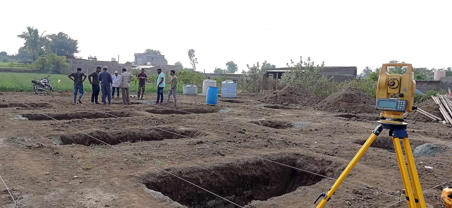
ትክክለኛውን ድንበር በ DGPS ወይም total station ይለኩ
በሻጩ አጥር ወይም በቃል መግለጫ አይመኑ። በቦታው ላይ የተለካ ድንበር ወደፊት ማረጋገጥ የሚችሉት መለኪያ ይሰጥዎታል።
የተለካውን ስፋት ከ7/12 ሰነድ ወይም የመሬት መዝገብ ጋር ያመሳክሩ
የተለካውን ስፋት ከግብር መዝገብ ጋር ያወዳድሩ። ትልቅ ልዩነት ካለ፣ ወደፊት ከመቀጠልዎ በፊት ማብራሪያ ያስፈልጋል፣ በኋላ አይደለም።
በአራቱም ጎኖች ወረራ ይፈትሹ
በህንድ ውስጥ ያሉ መሬቶች፣ በተለይ ከከተማ አቅራቢያ ባሉ አካባቢዎች፣ በጎረቤት ግንባታ ወይም ያለፈቃድ በተሰሩ አጥሮች ምክንያት ከጊዜ በኋላ በትንሹ ይቀንሳሉ። ቅየሳ ይህንን በእያንዳንዱ ጥግ ላይ በግልጽ ያሳያል።
የመሬት መግቢያ መብት ያረጋግጡ
የመግቢያ መንገዱ የህዝብ መንገድ መሆኑን ያረጋግጡ፤ በሌላ ሰው ንብረት በኩል የሚያልፍ ከሆነ፣ ይህ ፈቃድ በጽሁፍ የተመዘገበ መሆኑን ያረጋግጡ።
ስለ ባለቤትነት እና ዕዳ ምርመራ ያድርጉ
ረጅም የባለቤትነት ታሪክን የሚሸፍን የተመዘገበ የባለቤትነት ሰነድ ከዕዳ ማረጋገጫ ጋር፣ ስውር ዕዳ ወይም መሬቱን የሚመለከት አለመግባባት አደጋን ይቀንሳል።
የመሬት አጠቃቀም ምደባ እና የመቀየር ሁኔታ ይፈትሹ
መሬቱ የግብርና ወይም ግብርና ያልሆነ መሆኑን ያረጋግጡ፤ ግንባታ ለማካሄድ ካሰቡ፣ የመቀየር ፈቃድ ቀድሞ ተሰጥቷል ወይስ አሁንም በመጠባበቅ ላይ መሆኑን ይፈትሹ።
የአጠቃቀም እቅድ ከመወሰንዎ በፊት የመሬት ሁኔታን ይገምግሙ
ቁልቁለት፣ የውሃ ፍሳሽ አቅጣጫ፣ እና ዝቅተኛ ቦታዎች የግንባታ ወጪን እና የጎርፍ አደጋን ይነካሉ፣ ጠፍጣፋ ፕላን ፈጽሞ በማያሳየው መንገድ።
የቅየሳ ሪፖርት በጽሁፍ ያግኙ፣ በቃል ማረጋገጫ ብቻ አይደለም
ከመለኪያዎች እና የድንበር ካርታ ጋር የተጻፈ ሪፖርት ብቻ ነው ጠበቃዎ፣ ባንክ፣ ወይም የግብር ቢሮ ጥያቄ በኋላ ሲነሳ ተቀባይነት የሚያገኘው።
ማንኛውንም ልዩነት ከምዝገባ በፊት ይፍቱ፣ በኋላ አይደለም
ቅየሳው እና ሰነዶቹ የማይመሳሰሉ ከሆነ፣ ውል ከመፈረምዎ በፊት ይህንን ይፍቱ። ከምዝገባ በኋላ ማስተካከል ማለት የመንግስት ሂደት እና ብዙ ጊዜ የህግ ወጪ ማለት ነው።
ገዢዎች ይህንን እርምጃ የሚዘሉት ለምንድን ነው፣ እና ለምን ጉዳት ይመልስባቸዋል
ገዢዎች መሬት ከመግዛት በፊት ቅየሳ የሚዘሉበት በጣም የተለመደው ምክንያት የጊዜ ጫና ነው፣ ጥሩ ዋጋ፣ ስምምነቱን በፍጥነት መዝጋት የሚፈልግ ሻጭ፣ ጉዳዮችን የሚያቀላጥፍ የሽያጭ ወኪል። በእኛ የመስክ ስራ ልምድ፣ በድንበር አለመግባባት ውስጥ የገቡ መሬቶች ማለት ይቻላል ሁልጊዜ የተገዙት በቃል ቃል ኪዳን እንጂ በቅየሳ ሪፖርት ላይ ተመስርተው አልነበረም። ቅየሳ አብዛኛውን ጊዜ የሚወስደው ጥቂት ቀናት ብቻ ነው። የድንበር አለመግባባት ግን ዓመታት ሊወስድ ይችላል።
ከመግዛት በፊት የቅየሳ ወጪ ከመሬቱ ዋጋ ጋር ሲነጻጸር በጣም ትንሽ ነው። ከአለመግባባት በኋላ ተመልሰን እንድንለካ የሚጠሩን መሬቶች ማለት ይቻላል ሁልጊዜ ከመሸጣቸው በፊት ገለልተኛ የድንበር ማረጋገጫ አልነበራቸውም።
ለቅየሳ የትኞቹ ሰነዶች ማምጣት እንዳለብዎ
በእውነት በመሬት ቅየሳ ሪፖርት ውስጥ ያለው
| ክፍል | የሚያረጋግጠው |
|---|---|
| የድንበር መለኪያ | ትክክለኛ፣ የተለኩ የመሬቱ ጥግ ቦታዎች |
| የተሰላ ስፋት | ከመስክ ቅየሳ የተገኘ ትክክለኛ ስፋት፣ ከመዝገብ ጋር የተመሳከረ |
| የወረራ ምልክቶች | ማንኛውም አጥር ወይም የግንባታ ድንበር ከህጋዊ ድንበር የተለየበት ቦታ |
| የመግቢያ ማረጋገጫ | የመሬት መግቢያ ህጋዊ ማረጋገጫ ያለው መሆኑ |
| የመሬት ሁኔታ ማስታወሻ | ለወደፊት ግንባታ ቁልቁለት እና የውሃ ፍሳሽ ምልከታ |
ቅየሳ ያረጋገጠውን መሬት ይግዙ፣ የማስታወቂያ ብሮሸር የገለጸውን አይደለም።
Trishunya ከመግዛት በፊት ቅየሳን የሚያከናውንበት መንገድ
የመስክ ቡድኖቻችን እያንዳንዱን የድንበር ጥግ በትክክለኛ መለኪያ ለማሰር DGPS እና RTK ቅየሳ ዘዴዎችን ይጠቀማሉ፣ ከሻጩ ሰነዶች ጋር ያመሳክራሉ፣ እና ገዢው በጠበቃ ወይም በባንክ ፊት ሊቆም የሚችል ሪፖርት ያቀርባሉ። የመሬቱ ሙሉ ምስል ሲያስፈልግ፣ ይህንን ቁልቁለት እና የውሃ ፍሳሽን ከሚሸፍኑ የመልክዓ ምድር ቅየሳ መረጃዎች ጋር እናጣምራለን፣ ምክንያቱም በህጋዊነት ንፁህ ድንበር እንኳ ለግንባታ መጥፎ ቦታ ሊሆን ስለሚችል ነው።
የመሬት ግዢን መቼም ቢሆን በሽያጭ ወኪል ጠፍጣፋ ፕላን ወይም በቃል ድንበር ጉብኝት ብቻ አይጨርሱ። ከምዝገባ በፊት በቦታው ላይ የተለካ የቅየሳ ሪፖርት ለማግኘት አጥብቀው ይጠይቁ።
መሬትን ለመፈረም ተዘጋጅተዋል?
ከመግዛት በፊት ትንሽ የድንበር ቅየሳ አሁን ካደረጉ ከአለመግባባት በኋላ ከሚደረግ ድጋሚ ቅየሳ በጣም ርካሽ ነው።
በተደጋጋሚ የሚጠየቁ ጥያቄዎች
የሽያጭ ሰነድ በወረቀት ላይ ህጋዊ ባለቤትነትን ያረጋግጣል፣ ነገር ግን በቦታው ላይ ያለው ትክክለኛ ድንበር ከተገለጸው ጋር የሚመሳሰል መሆኑን አያረጋግጥም። ይህንን ማረጋገጥ የሚችለው የመሬት ቅየሳ ብቻ ነው።
ለተለመደ የመኖሪያ ወይም የግብርና መሬት፣ ቅየሳ እና ሪፖርት በተለምዶ በጥቂት ቀናት ውስጥ ይጠናቀቃል፣ ይህም በመሬቱ መጠን፣ በመልክዓ ምድር ሁኔታ፣ እና ወደ ቦታው በመድረስ ላይ ይወሰናል።
በአጥር ወይም በጎረቤት ግንባታ ምክንያት የሚፈጠር የድንበር ወረራ በጣም የተለመደው ችግር ነው፣ ከዚያም ከአሮጌ የግብር መዝገቦች ጋር ሲነጻጸር የሚታይ የስፋት ልዩነት ይከተላል።
ከተለካ መለኪያዎች ጋር የተጻፈ የቅየሳ ሪፖርት፣ ከባለቤትነት እና ግብር መዝገቦች ጋር፣ በድንበር አለመግባባቶች ውስጥ የሚደግፍ ቴክኒካዊ ማስረጃ ሆኖ በተለምዶ ጥቅም ላይ ይውላል።
በፊት። ውል ከመፈረም በፊት በቅየሳ የተገኘውን ማንኛውንም ልዩነት መደራደር ወይም ማላቀቅ ከምዝገባ በኋላ ከማድረግ ይልቅ በጣም ቀላል ነው።
DGPS ቅየሳ የሳተላይት አቀማመጥን በመጠቀም እያንዳንዱን የድንበር ጥግ በትክክለኛ መለኪያ ያስራል፤ የቴፕ መለኪያ በእጅ የሚደረግ ሲሆን፣ ቀርፋፋ ነው፣ እና በትላልቅ ወይም መደበኛ ያልሆነ ቅርጽ ባላቸው መሬቶች ላይ የስህተት እድል በጣም ከፍተኛ ነው።
አካላዊ ቅየሳ ትኩረቱ በድንበር እና ስፋት ላይ ነው። የመሬት አጠቃቀም ምደባ እና የመቀየር ሁኔታ የተለየ ምርመራ ነው፣ ብዙውን ጊዜ ከቅየሳ ጎን ለጎን ከከተማ ማዘጋጃ ቤት ወይም ግብር መዝገቦች ጋር ይረጋገጣል።
ይህንን ጉዳይ ወደፊት ከመቀጠልዎ በፊት ለሻጩ እና ለጠበቃዎ ያቅርቡ። ትንሽ ልዩነት በአሮጌ የቅየሳ ዘዴዎች ሊገለጽ ይችላል፣ ነገር ግን ትልቅ ልዩነት ገንዘብ ከመክፈልዎ በፊት ምርመራ ያስፈልገዋል።
በዓለም አቀፍ ደረጃ ለሁሉም ግብይት ህጋዊ ግዴታ አይደለም፣ ነገር ግን እንደ ምርጥ ተግባር በጣም ይመከራል፣ አንዳንድ ግዛቶች ደግሞ ለተወሰኑ የመሬት ዓይነቶች ወይም ለተከፋፈሉ መሬቶች ይህንን ግዴታ ያደርጋሉ።
DGPS ወይም total station መሳሪያ ያለው፣ እና ከመደበኛ ያልሆነ ቅየሳ ይልቅ ለህጋዊ እና ምዝገባ ፍላጎቶች የሚስማሙ ሪፖርቶችን በማዘጋጀት ልምድ ያለው ፈቃድ ያለው የቅየሳ ቡድን ይጠቀሙ።
ይህ መስመር ለስራ ጥያቄዎች ብቻ ነው። እባክዎ ለትምህርት፣ ስልጠና፣ ወይም ስራ ፍለጋ አያገናኙ።