ড্রোন দ্বারা NHAI হাইওয়ে করিডোর সমীক্ষা: একটি পূর্ণাঙ্গ পর্যালোচনা
একটি হাইওয়ে অ্যালাইনমেন্ট সার্ভের রূপরেখা সাধারণ জমির মতো চারকোনা হয় না। এটি কয়েক ডজন কিলোমিটার জুড়ে বিস্তৃত একটি দীর্ঘ ও সংকীর্ণ ফিতার মতো, এবং এটি দক্ষতার সাথে ম্যাপ করা চিরাচরিত গ্রিড সার্ভের চেয়ে সম্পূর্ণ আলাদা পরিকল্পনার দাবি রাখে।
NHAI হাইওয়ে প্রকল্পগুলিতে প্রস্তাবিত রুটের অ্যালাইনমেন্ট ডেটা, বিদ্যমান ইউটিলিটি ক্রসিং এবং ভূখণ্ডের প্রোফাইল দ্রুত সংগ্রহ করতে ড্রোন ভিত্তিক করিডোর সার্ভের উপর ব্যাপকভাবে নির্ভর করা হচ্ছে। এই লিনিয়ার গঠন ফ্লাইট পরিকল্পনা, গ্রাউন্ড কন্ট্রোল পয়েন্ট স্থাপন এবং ডেটা প্রসেসিং পদ্ধতিকে প্রচলিত এরিয়া সার্ভে থেকে আলাদা করে তোলে।
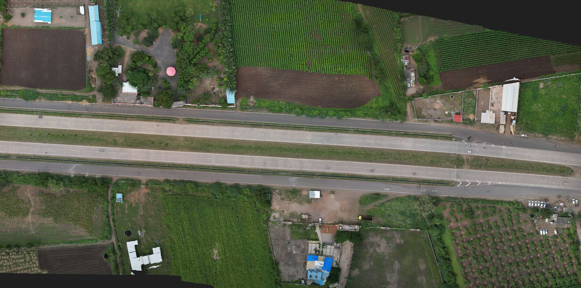
করিডোর সার্ভে ফ্লাইটের লাইভ অ্যানিমেশন দেখুন
হাইওয়ে অ্যালাইনমেন্ট ফ্লাইট পাথ
করিডোরের প্রস্থ পরিবর্তন করে কভারেজ দেখুন
করিডোর কভারেজ প্রস্থ টুল
রুট বরাবর সমীক্ষার অগ্রগতির সিমুলেশন দেখুন
করিডোর সার্ভে অগ্রগতি
করিডোর সার্ভের পরিকল্পনা কেন আলাদা হয়
| দিক | এরিয়া সার্ভে (যেমন প্লট) | করিডোর সার্ভে (যেমন হাইওয়ে) |
|---|---|---|
| ফ্লাইট প্যাটার্ন | নির্দিষ্ট এলাকা কভার করা গ্রিড প্যাটার্ন | অ্যালাইনমেন্ট অনুসরণকারী রৈখিক প্যাটার্ন |
| GCP স্থাপন | সমগ্র এলাকা জুড়ে বিন্যস্ত | রুট বরাবর নির্দিষ্ট ব্যবধানে স্থাপিত |
| প্রধান আউটপুট | সম্পূর্ণ এলাকার অর্থোমোজাইক ও DTM | অ্যালাইনমেন্ট প্রোফাইল, ক্রস-সেকশন, ইউটিলিটি ক্রসিং |
| উৎপাদনশীলতার একক | একর প্রতি দিন | কিলোমিটার প্রতি দিন |
NHAI কর্তৃক ড্রোন ভিত্তিক করিডোর সমীক্ষার ক্রমবর্ধমান ব্যবহার পরিকাঠামোর আধুনিক অগ্রগতিকে তুলে ধরে: লিনিয়ার প্রকল্পগুলিকে চারকোনা গ্রিডে বাধ্য না করে তাদের নিজস্ব রৈখিক পথে সমীক্ষা করলে সর্বোত্তম নির্ভুলতা অর্জিত হয়।
একটি হাইওয়ে কখনো চারকোনা গ্রিডে খাপ খায় না। এটিকে তার বাস্তব রৈখিক রূপেই সমীক্ষা করুন।
করিডোর সার্ভে ডেটা যেভাবে কাজে লাগে
অ্যালাইনমেন্টের ভূপ্রকৃতি প্রোফাইল, বিদ্যমান ইউটিলিটি ক্রসিং পয়েন্ট এবং ড্রেনেজ প্যাটার্ন সরাসরি সড়ক নকশার সিদ্ধান্তে ব্যবহৃত হয়। আমাদের ড্রোন সার্ভে দল অ্যালাইনমেন্ট কেন্দ্রিক ফ্লাইট পরিকল্পনা করে এবং সিভিল ইঞ্জিনিয়ারদের প্রয়োজনীয় টপোগ্রাফিক ক্রস-সেকশন সরবরাহ করে।
আপনি কি সড়ক, পাইপলাইন বা রেল প্রকল্পের জন্য লিনিয়ার সার্ভে পরিকল্পনা করছেন?
আমাদের রুটের দৈর্ঘ্য ও ভূপ্রকৃতি জানান, আমরা একটি নির্দিষ্ট করিডোর ফ্লাইট পরিকল্পনা তৈরি করব।
সাধারণ জিজ্ঞাসা
করিডোর সার্ভে হল চতুর্ভুজ এলাকার পরিবর্তে প্রস্তাবিত হাইওয়ের মতো দীর্ঘ রৈখিক রুটের ভূপ্রকৃতি ও অ্যালাইনমেন্ট ডেটা সংগ্রহ করা।
ড্রোন স্থলভিত্তিক পদ্ধতির চেয়ে অনেক দ্রুত দীর্ঘ রুট কভার করে এবং সঠিক নকশার জন্য প্রয়োজনীয় ডেটা প্রদান করে।
করিডোর ফ্লাইট গ্রিডের বদলে রৈখিক পথ অনুসরণ করে এবং গ্রাউন্ড কন্ট্রোল পয়েন্টগুলিও রুটের সাথে বিন্যস্ত থাকে।
অ্যালাইনমেন্ট প্রোফাইল, ক্রস-সেকশন, ইউটিলিটি ক্রসিং পয়েন্ট এবং ড্রেনেজ প্যাটার্ন ডেটা এর প্রধান ফলাফল।
সাধারণ সার্ভের একর প্রতি দিনের বদলে করিডোর সার্ভে পরিমাপ করা হয় প্রতিদিন কভার করা কিলোমিটারের ভিত্তিতে।
প্রশস্ত করিডোর চারপাশের অতিরিক্ত তথ্য দেয়, তবে এর জন্য অতিরিক্ত ফ্লাইট লাইনের প্রয়োজন হয় যা প্রক্রিয়াকরণের সময় বাড়ায়।
উপরিভাগে দৃশ্যমান ইউটিলিটি ক্রসিং সহজেই শনাক্ত করা যায়, তবে ভূগর্ভস্থ সুবিধার জন্য GPR স্ক্যানের প্রয়োজন হয়।
হ্যাঁ, একই রৈখিক সমীক্ষা পদ্ধতি রেললাইন, গ্যাস পাইপলাইন এবং পাওয়ার ট্রান্সমিশন করিডোরেও কার্যকর।
ভূপ্রকৃতির উপর নির্ভর করলেও ড্রোন সমীক্ষা প্রচলিত পদ্ধতির তুলনায় বহু গুণ দ্রুত সম্পন্ন হয়।
হ্যাঁ, আমাদের DTM এবং ক্রস-সেকশন ডেটা Civil 3D সহ প্রধান রোড ডিজাইন সফটওয়্যারে সরাসরি ব্যবহারের উপযোগী।
এই লাইনটি শুধুমাত্র প্রকল্পের অনুসন্ধানের জন্য সংরক্ষিত। প্রশিক্ষণ বা চাকরির জন্য যোগাযোগ করবেন না।