ለቆፈራ ሥራ የባቲሜትሪ ቅኝት፦ የመጠን መጠንን በትክክል መለካት
የቆፈራ ውሎች አብዛኛውን ጊዜ ክፍያ የሚፈጸምላቸው በተወገደው ቁሳቁስ መጠን ልክ በመሆኑ፣ ትክክለኛ ከቆፈራ በፊት እና በኋላ የሚደረጉ የባቲሜትሪ ቅኝቶች በቀጥታ ከገንዘብ ጋር የተያያዙ ናቸው። ቅኝቱን ዝቅ አድርጎ መገመት ተራራጁን ወይም ደንበኛውን ከፍትሐዊ የክፍያ ስሌት ውጪ ያደርጋቸዋል።
ሂሳቡ በቀላሉ ቀጥተኛ ነው፦ ከቆፈራው በፊት የታችኛውን ወለል መቃኘት፣ ከቆፈራው በኋላ እንደገና መቃኘት፣ እና በሙሉ የፕሮጀክቱ ክልል ላይ ያለውን የመጠን ልዩነት ማስላት። የሁለቱም ቅኝቶች ትክክለኛነት የመጨረሻው ቁጥር ምን ያህል ተአማኒ እንደሚሆን ይወስናል።
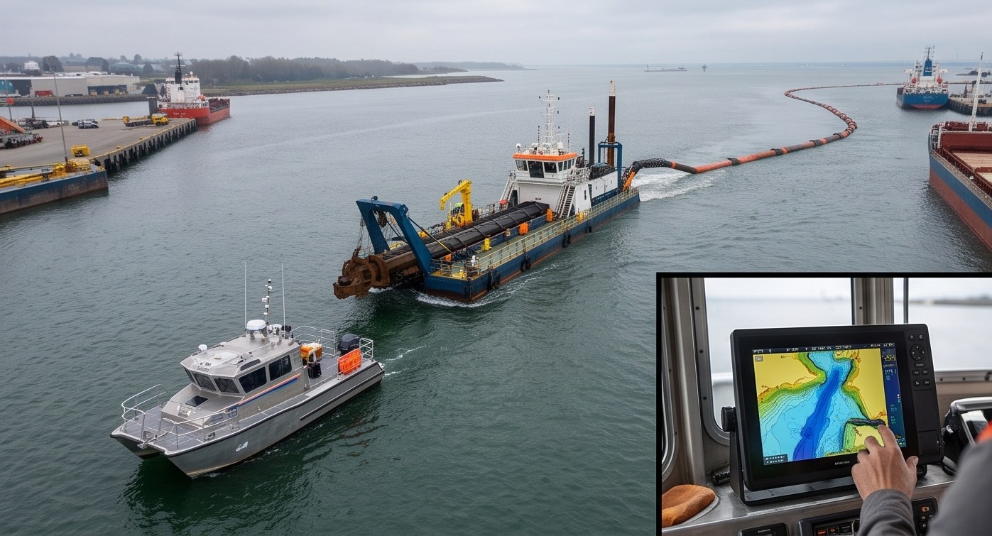
የቆፈራ መጠን ሲከማች ይመልከቱ
የቀጥታ የቆፈራ መጠን ተከታታይ
ወደ ታላመደው ጥልቀት ያለውን እድገት ይከታተሉ
በይነተገናኝ የቆፈራ እድገት ሲሙሌተር
ከቆፈራ በፊት እና በኋላ ያሉትን መገለጫዎች ያወዳድሩ
ለማወዳደር በጎንዮሽ ቅርጽ (Cross Section) ላይ ይጫኑ
የቆፈራ መጠን ቅኝቶች እንዴት እንደሚሠሩ
ከቆፈራ በፊት የሚደረግ የባቲሜትሪ ቅኝት
ሙሉ የሶናር ቅኝት በሙሉ የቆፈራ ፕሮጀክት ክልል ላይ የመነሻ የታችኛውን ወለል ከፍታ ያዘጋጃል።
የቆፈራ ክዋኔ ክትትል
በቆፈራ ወቅት የሚደረጉ የእድገት ቅኝቶች ከታለመው ጥልቀት አንጻር ምን ያህል ቁሳቁስ እንደተወገደ ይከታተላሉ።
ከቆፈራ በኋላ የሚደረግ የማረጋገጫ ቅኝት
የመጨረሻ ቅኝት የተጠናቀቀው ጥልቀት በሙሉ ክልሉ ላይ ከፕሮጀክቱ ዝርዝር መግለጫዎች ጋር እንደሚመሳሰል ያረጋግጣል።
የመጠን ልዩነት ስሌት
ሶፍትዌር በፕሮጀክቱ ክልል ላይ ከቆፈራ በፊት እና በኋላ ባሉት ወለሎች መካከል ያለውን ጠቅላላ የመጠን ልዩነት ያሰላል።
የክፍያ እና የህግ ተገዢነት ሪፖርት
የመጨረሻው የመጠን ሪፖርት የተራራጁን ክፍያ ስሌቶች እና የህግ ተገዢነት ሰነዶችን ይደግፋል።
መልቲ-ቢም ሶናር ለቆፈራ ቅኝቶች በጣም ተመራጭ ነው፤ ምክንያቱም ሙሉ የታችኛውን ወለል ሽፋን በመስጠት፣ በሲንግል-ቢም ክፍተቶች ሊደበቁ የሚችሉ ያልተቆፈሩ ከፍተኛ ቦታዎችን ወይም ያላነሰ የቆፈራ ስጋቶችን ያስወግዳል።
በቆፈራ ሥራ ውስጥ ቅኝት የይስሙላ ሥነ-ሥርዓት አይደለም፤ እርሱ ራሱ ደረሰኙ ነው።
የተረጋገጠ የቆፈራ መጠን መረጃ ማግኘት
ትክክለኛ የመጠን ስሌት ተራራጆች እና ደንበኞችን በእርግጥ ስለተወገደው ቁሳቁስ ከሚነሱ አለመግባባቶች ይጠብቃል። የእኛ የድሮን ቅኝት ቡድን ለቆፈራ ፕሮጀክቶች ከሙሉ መልቲ-ቢም ሽፋን ጋር ከቆፈራ በፊት እና በኋላ የሚደረጉ የባቲሜትሪ ቅኝቶችን ያካሂዳል።
የቆፈራ መጠን ማረጋገጫ ይፈልጋሉ?
ስለ ፕሮጀክትዎ ይንገሩን እና ከቆፈራ በፊት እና በኋላ የምንጠቀምበትን የቅኝት አቀራረብ እናብራራለን።
ተደጋግመው የሚጠየቁ ጥያቄዎች
ከቆፈራ በፊት የሚደረግ ቅኝት የመነሻ ከፍታን ያዘጋጃል፤ ከቆፈራ በኋላ የሚደረግ ቅኝት ደግሞ የተጠናቀቀውን ጥልቀት ያረጋግጣል፤ ሁለቱም አንድ ላይ የተወገደውን ትክክለኛ መጠን ያሰላሉ።
ሶፍትዌር ከቆፈራ በፊት እና በኋላ ባሉት የታችኛው ወለል ከፍታዎች መካከል ያለውን ልዩነት ያሰላል፤ እንዲሁም ያንን ልዩነት በሙሉ የፕሮጀክት ክልል ላይ ያቀናጃል።
መልቲ-ቢም ሙሉ የታችኛውን ወለል ሽፋን ይሰጣል፤ ይህም ሲንግል-ቢም ሶናር ሊተዋቸው የሚችላቸውን እና ያልተቆፈሩ ቦታዎችን ወይም ያልታዩ ከፍተኛ ቦታዎችን ሊደብቁ የሚችሉ ክፍተቶችን ያስወግዳል።
አዎ፣ ብዙ የቆፈራ ውሎች ክፍያ የሚፈጽሙት በተረጋገጠው የተወገደ መጠን ላይ ተመስርተው ነው፤ ይህም ትክክለኛ የቅኝት መረጃ በቀጥታ ከፕሮጀክት ሂሳብ አከፋፈል ጋር ተያያዥነት እንዲኖረው ያደርገዋል።
አዎ፣ በቆፈራ ወቅት የሚደረጉ ጊዜያዊ ቅኝቶች ወደ ታለመው ጥልቀት ያለውን እድገት ለመከታተል ይረዳሉ፤ እንዲሁም ከመጠናቀቁ በፊት በክዋኔዎች ላይ ማስተካከያ ለማድረግ መረጃ ይሰጣሉ።
ከፍተኛ የቁመት (vertical) ትክክለኛነት አስፈላጊ ነው፤ ምክንያቱም ትናንሽ የጥልቀት ስህተቶች እንኳ በትልቅ የቆፈራ ቦታ ላይ ሲቀናጁ በከፍተኛ ሁኔታ ይከማቻሉ።
አዎ፣ የተሳሳተ ወይም ያልተሟላ የቅኝት መረጃ በተራራጆች እና ደንበኞች መካከል በእርግጥ በተወገደው ቁሳቁስ መጠን ላይ የክፍያ አለመግባባቶችን ሊያስከትል ይችላል።
የተለመዱ ውጤቶች ከቆፈራ በፊት እና በኋላ ያሉ የባቲሜትሪ ካርታዎችን፣ የመጠን ልዩነት ሪፖርትን እና ለክፍያ ወይም ለህግ ተገዢነት ዓላማዎች የሚሆኑ დამደገፊ ሰነዶችን ያካትታሉ።
አዎ፣ የተረጋገጠ የቅኝት መረጃ ከቆፈራ ፈቃዶች እና ክዋኔዎች ጋር የተያያዙ ለአካባቢ ጥበቃ እና ህጋዊ ሪፖርት መስፈርቶችን አብዛኛውን ጊዜ ይደግፋል።
የመጨረሻ የማረጋገጫ ቅኝቶች አብዛኛውን ጊዜ ከቆፈራ መጠናቀቅ በኋላ ወዲያውኑ ይደረጋሉ፤ ይህም ማንኛውም ተፈጥሯዊ የደቃቅ አፈር (sediment) ሽግግር ከመከሰቱ በፊት የተጠናቀቀውን ሁኔታ በትክክል ለመቅረጽ ነው።
ይህ መስመር ለፕሮጀክት መሪዎች ብቻ የተያዘ ነው። እባክዎን ለትምህርት፣ ስልጠና ወይም የሥራ ጥያቄዎች አይገናኙ።