የዲጂፒኤስ ቅኝት vs መደበኛ ጂፒኤስ፡ ትክክለኛነት፣ ወጪ እና የተሻለው አማራጭ
የስማርትፎን ጂፒኤስ ትክክለኛ ቦታዎን በ 10 ሜትር ልዩነት ውስጥ ሊያሳይ ይችላል፤ ይህም ምግብ ቤት ለማግኘት በቂ ቢሆንም ህጋዊ የመሬት ወሰንን ለመወሰን ግን ፈጽሞ የማይጠቅም ነው። ይህ እንደ ትንሽ ክፍል ወይም ሙሉ ህንፃ ስፋት ያለው ልዩነት የዲጂፒኤስ (DGPS) ቅኝት ከተለመደው ጂፒኤስ የተለየ የምህንድስና ዘርፍ እንዲሆን ያደረገው ዋና ምክንያት ነው።
መደበኛ ጂፒኤስ እና ዲጂፒኤስ ሁለቱም የሳተላይት ምልክቶችን ይጠቀማሉ፣ ነገር ግን ሙሉ በሙሉ የተለያዩ የምህንድስና ፍላጎቶችን ያሟላሉ። መደበኛ ጂፒኤስ ግምታዊ ቦታን በፍጥነት እና በነጻ ይሰጣል። ዲጂፒኤስ ደግሞ ለእውነተኛ ጊዜ ስህተቶችን በማረም ለወሰን እና ለግንባታ ፕሮጀክቶች አስተማማኝ የሆነ የቅኝት ደረጃ ትክክለኛነትን ያረጋግጣል።
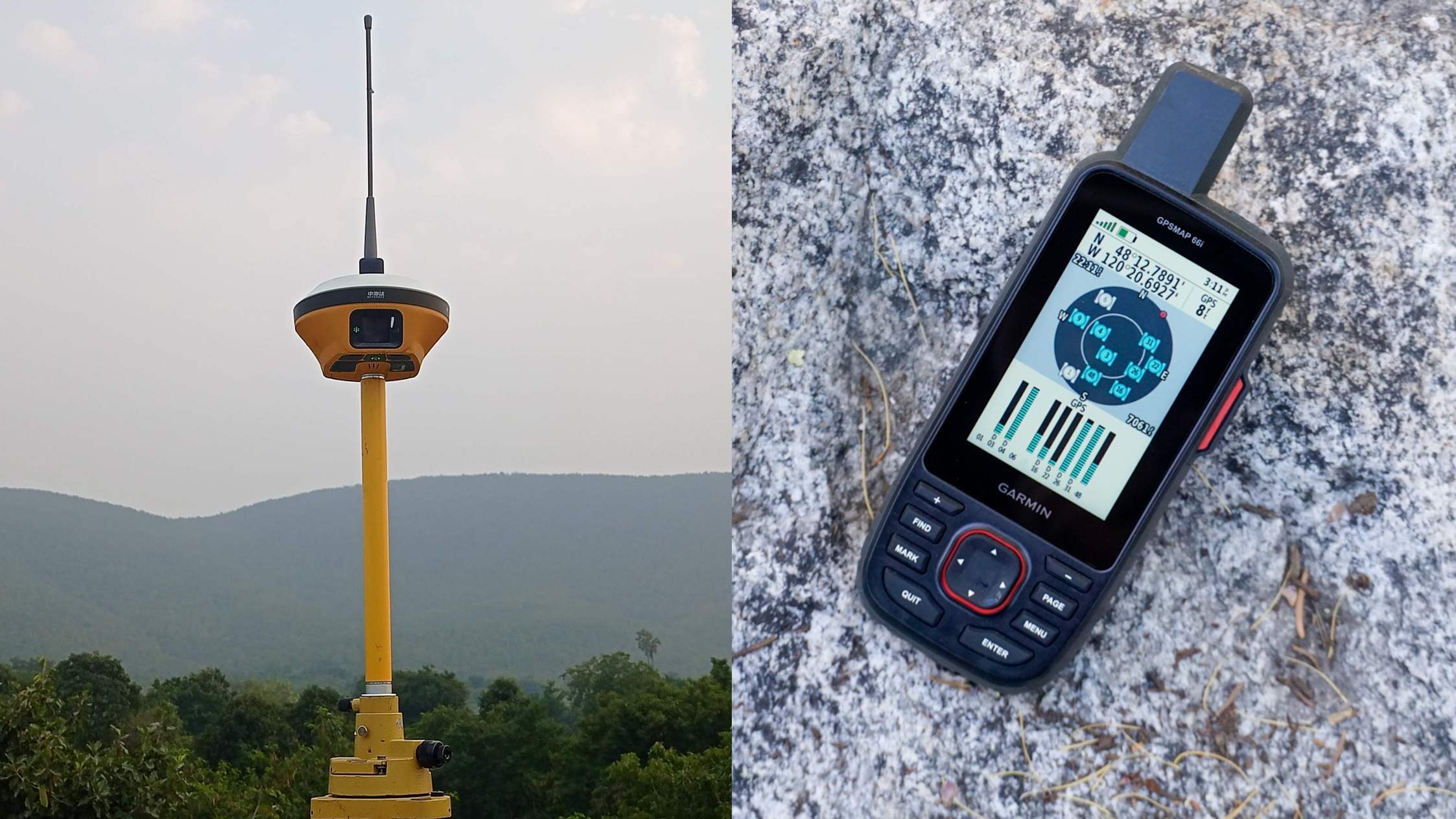
መደበኛ ጂፒኤስ እንዴት ይሰራል
መደበኛ የጂፒኤስ ተቀባይ (እንደ ስልክ ያለ) ቦታን የሚያሰላው ከሳተላይት ምልክቶች ብቻ ነው። በከባቢ አየር መስተጓጎል እና በምልክት መዘግየት ምክንያት ከ 3 እስከ 10 ሜትር፣ ያለ እርማት ደግሞ አንዳንዴ ከ 15 ሜትር በላይ ስህተት ይከሰታል። ይህ የመንገድ አቅጣጫን ለማወቅ ጥሩ ቢሆንም ህጋዊ የመሬት ወሰን ለማካለል ወይም ለግንባታ ስራ ግን ተቀባይነት የለውም።
ዲጂፒኤስ ትክክለኛነትን እንዴት ያሻሽላል
የዲጂፒኤስ ቅኝት ሁለት ተቀባዮችን ይጠቀማል፡ በትክክል በሚታወቅ ነጥብ ላይ የተቀመጠ ቋሚ ቤዝ ስቴሽን (Base Station) እና በመስክ ላይ የሚንቀሳቀስ ሮቨር (Rover)። ቤዝ ስቴሽኑ የሳተላይት ምልክት ስህተትን በእውነተኛ ጊዜ በማስላት ወደ ሮቨሩ እርማቶችን ይልካል፣ ይህም የከባቢ አየር ስህተቶችን ያስቀራል። በዚህም ከ 1 ሴንቲሜትር እስከ ግማሽ ሜትር የሚደርስ ከፍተኛ ትክክለኛነት ይገኛል።
መደበኛ ጂፒኤስ
- ትክክለኛነት፡ ከ 3 እስከ 15 ሜትር
- ነጠላ ተቀባይ፣ የማረሚያ ስርዓት የለውም
- ነጻ ወይም በጣም ዝቅተኛ ወጪ
- ለአቅጣጫ መጠቆሚያ እና ለአጠቃላይ ቦታ ምቹ
የዲጂፒኤስ ቅኝት
- ትክክለኛነት፡ ከ 1 ሴ.ሜ እስከ 0.5 ሜትር
- የቤዝ ስቴሽን እና የሮቨር ጥምር ስርዓት
- የላቀ የሙያ መሳሪያ እና ኢንጂነሪንግ ወጪ
- ለካዳስተር፣ ለወሰን ማካለል እና ለመሰረተ ልማት ምርጥ
የወጪ እና የአሰራር ንፅፅር
| የንፅፅር መስፈርት | መደበኛ ጂፒኤስ | የዲጂፒኤስ ቅኝት |
|---|---|---|
| የተለመደ ትክክለኛነት | ከ 3 እስከ 15 ሜትር | ከ 1 ሴንቲሜትር እስከ 0.5 ሜትር |
| የሚያስፈልገው መሳሪያ | ተራ ስልክ / ተቀባይ | የቤዝ ስቴሽን + ሮቨር የቅኝት ስርዓት |
| ወጪ | በጣም ዝቅተኛ (በስልክ ውስጥ) | በቀን ከ ₹8,000 እስከ ₹25,000 ወይም በኪ.ሜ |
| ምርጥ አጠቃቀም | አቅጣጫ ማወቅ፣ አጠቃላይ ቦታ | የካዳስተር ቅኝት፣ የወሰን ምልክት፣ ግንባታ |
በህንድ እና በዓለም አቀፍ ደረጃ በካዳስተር እና በመንግስት የመሰረተ ልማት ፕሮጀክቶች ላይ ዲጂፒኤስ ግዴታ ነው፤ ምክንያቱም የመደበኛ ጂፒኤስ ስህተት ለህጋዊ ወይም ለምህንድስና ውሳኔዎች በጣም ትልቅ ነው።
ከመደበኛ ጂፒኤስ ይልቅ ዲጂፒኤስ በእርግጥ የሚያስፈልግዎት መቼ ነው
የመለኪያ ውጤቶች ህጋዊ የመሬት ባለቤትነት ወሰኖችን ወይም የግንባታ ንድፎችን የሚነኩ ከሆነ ዲጂፒኤስ የግድ ነው። መደበኛ ጂፒኤስ የሚያገለግለው የጥቂት ሜትሮች ልዩነት ምንም ጉዳት በማያስከትልበት ስራ ላይ ብቻ ነው። የእኛ የ DGPS and RTK survey አገልግሎት ከፍተኛውን የትክክለኛነት መስፈርት ለማሟላት የተዘጋጀ ነው።
በጂፒኤስ እና በዲጂፒኤስ መካከል ያለው ልዩነት በግምት የት እንዳሉ ከማወቅ እና የንብረትዎ ወሰን በትክክል የት እንደሚያበቃ በእርግጠኝነት ከማወቅ መካከል ያለው ልዩነት ነው።
በዲጂፒኤስ የተመሰረቱ የመሬት መቆጣጠሪያ ነጥቦች (GCPs) የድሮን ቅኝት መረጃን ወደ ምህንድስና ትክክለኛነት ያገናኛሉ፣ ይህም ለሁሉም topographic ካርታዎች መሰረት ነው።
በመሬት ክርክሮች ወይም በግንባታ ማካለል ላይ የስማርትፎን ጂፒኤስ መረጃዎችን እንደ ማስረጃ በፍጹም አይጠቀሙ። የእሱ ስህተት በህግም ሆነ በቴክኒክ ተቀባይነት የለውም።
ለፕሮጀክትዎ የቅኝት ደረጃ ትክክለኛነት ያስፈልግዎታል?
የቦታዎን ዝርዝር እና አላማ ይንገሩን፣ እኛም ዲጂፒኤስ ወይስ RTK ይበልጥ ተስማሚ እንደሆነ እናረጋግጣለን።
ተደጋግመው የሚጠየቁ ጥያቄዎች (FAQ)
መደበኛ ጂፒኤስ ከ 3 እስከ 15 ሜትር ስህተት ሲኖረው፣ ዲጂፒኤስ በቤዝ ስቴሽን እርዳታ ከ 1 ሴ.ሜ እስከ 0.5 ሜትር ትክክለኛነት ይሰጣል።
ምክንያቱም ዲጂፒኤስ በሚታወቅ ነጥብ ላይ ቤዝ ስቴሽን በማስቀመጥ የሳተላይት ስህተቶችን በእውነተኛ ጊዜ ስለሚያርም ነው።
አይችሉም። የስልክ ጂፒኤስ የበርካታ ሜትሮች ስህተት ስላለው ለህጋዊ ወሰን መወሰኛ አይሆንም።
በተለምዶ በቀን ከ ₹8,000 እስከ ₹25,000 ወይም ለመንገድ ፕሮጀክቶች በኪሎሜትር ከ ₹1,500 እስከ ₹4,000 ነው።
ሁለት የቅኝት ደረጃ ተቀባዮች ያስፈልጋሉ፡ ቋሚ ቤዝ ስቴሽን እና ተንቀሳቃሽ ሮቨር።
በጣም ተመሳሳይ ናቸው። RTK በመስክ ላይ ወዲያውኑ የተስተካከለ መረጃ ይሰጣል፣ አንዳንድ ዲጂፒኤስ ደግሞ ከስራ በኋላ ይስተካከላሉ።
አዎ፣ ለህጋዊ እና ለምህንድስና ደህንነት ሲባል በመንግስት ፕሮጀክቶች ላይ የዲጂፒኤስ መስፈርት ግዴታ ነው።
አዎ፣ ዲጂፒኤስ በሳተላይት እና ቀጥታ የሬዲዮ ግንኙነት ላይ ስለሚሰራ የሞባይል ኔትወርክ አያስፈልገውም።
ወሰንን በህጋዊ መንገድ ለማረጋገጥ አዎ፣ ምክንያቱም የጥቂት ሜትሮች ስህተት ትልቅ ክርክር ሊፈጥር ይችላል።
ሁለቱም ከፍተኛ ትክክለኛነት ይሰጣሉ። በክፍት ሜዳ ላይ ዲጂፒኤስ በጣም ፈጣን ሲሆን፣ በከተሞች ደግሞ ቶታል ስቴሽን ይመረጣል።
ይህ መስመር ለፕሮጀክት ጥያቄዎች ብቻ የተያዘ ነው። እባክዎን ለስራ ወይም ለስልጠና ጥያቄዎች አይገናኙ።