የዩኤስቪ ባቲሜትሪ ጥናት፡ ሰው አልባ ጀልባዎች የውሃ ጥልቀት ካርታ ስራ
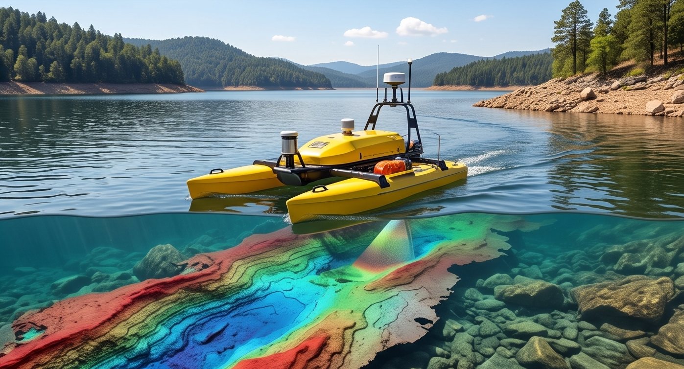
ሰው የያዘች ጀልባን ጥልቀት የሌለው፣ አደገኛ ወይም የተበከለ ውሃ ውስጥ መላክ ከፍተኛ የህይወት አደጋ ያጋጥማል። ሰው አልባ የውሃ ላይ ተሽከርካሪዎች (USV) የሰውን አደጋ ሙሉ በሙሉ በማስቀረት፣ የሶናር መሳሪያዎችን በውሃ ላይ በራስ-ሰር በመሸከም በጥናት ቡድኑ ከባህር ዳርቻ ሆኖ ቁጥጥር ይደረግበታል።
ከደህንነት በተጨማሪ፣ USV ከፍተኛ ወጥነትን ያመጣል። አስቀድሞ የተዘጋጀ የጥናት መስመር በሰው ሰራሽ ጀልባ ነጂ የሰአታት ድካም ምክንያት ከሚፈጠር ተፈጥሯዊ መዛባት ነፃ በሆነ መልኩ በየጊዜው በተመሳሳይ ትክክለኛነት ይከተላል።
የUSV ጥናትን በተግባር ይመልከቱ
ቀጥታ አውቶማቲክ የጥናት ሲሙሌሽን
የUSV ጥናት መስመርን ያቅዱ
ኢንተራክቲቭ የመንገድ ነጥብ (Waypoint) አቀናጅ
የአደጋ እንቅፋቶች መሸሻን ያስካክሉ
የእንቅፋት መከላከያ ክልል ሲሙሌተር
የUSV ባቲሜትሪክ ጥናት እንዴት እንደሚሰራ
የተልዕኮ እቅድ ማውጣት
የጥናት መስመሮች እና የመንገድ ነጥቦች በሚያስፈልገው የሽፋን ስፋት እና ጥራት መሰረት አስቀድመው የተቀረፃሉ።
በራስ-ሰር ስራ መጀመር
USV በGPS እና በውስጡ ባሉ ሴንሰሮች በመታገዝ የታቀደውን መስመር በራሱ መንገድ በመከተል ይጓዛል።
የማያቋርጥ የሶናር ምዝገባ
በጀልባው ላይ ያለው የሶናር ሲስተም ተሽከርካሪው በሚንቀሳቀስበት ጊዜ በየጥናት መስመሩ ላይ ጥልቀቱን በተከታታይ ይመዘግባል።
እንቅፋቶችን መለየት እና መሸሽ
የውስጥ ሴንሰሮች እንቅፋቶችን በመለየት ደህንነቱ የተጠበቀ አሰራርን ለመጠበቅ አቅጣጫውን በራስ-ሰር ያስካክላሉ።
ከሩቅ ሆኖ መቆጣጠር
በባህር ዳርቻ ላይ ያለ ኦፕሬተር ሂደቱን የሚከታተል ሲሆን ሁኔታዎች ካስገደዱ በእጅ ቁጥጥር ማድረግ ይችላል።
USVዎች ሰው የያዘች ጀልባ የመሬት መንካት አደጋ በሚያጋጥማት ጥልቀት የሌለው ውሃ፣ የተበከለ ወይም አደገኛ ውሃ ውስጥ፣ እና ትልልቅ ጀልባዎች መዞር በማይችሉበት እንደ ጠባብ ካናሎች ባሉ ቦታዎች የላቀ ብቃት ያሳያሉ።
ሰራተኞችን ከጀልባው ላይ ማንሳት ጥናቱን አያስቀረውም። አደጋውን ያስቀረዋል እንጂ።
የUSV ጥናትን መቼ ማሰብ ይገባል
የግድብ ውሃዎች፣ የከተማ የውሃ አካላት፣ የተበከሉ ቦታዎች እና ጥልቀት የሌላቸው ወንዞች ለሰው አልባ ጥናት በጣም ተስማሚ ናቸው። የኛ የድሮን ጥናት ቡድን ሰው የያዙ ጀልባዎች አላስፈላጊ አደጋ ወይም የመግባት ችግር በሚፈጥሩባቸው የባቲሜትሪክ ፕሮጀክቶች ላይ የUSV ፕላትፎርሞችን ይጠቀማል።
ለመድረስ አስቸጋሪ የሆነ እና መለካት የሚፈልጉት የውሃ አካል አለዎት?
ስለ ቦታዎ ይንገሩን እና የUSV አቀራረብ ተስማሚ መሆኑን እንገልጽልዎታለን።
ተደጋግመው የሚጠየቁ ጥያቄዎች
USV (Unmanned Surface Vehicle) ማለት በጀልባዋ ላይ ሰራተኛ ሳያስፈልግ የሶናር መሳሪያዎችን በውሃ ላይ በራስ-ሰር የሚሸከም ሰው አልባ ጀልባ ነው።
USV በአደገኛ ወይም ጥልቀት የሌለው ውሃ ውስጥ የሰራተኞችን አደጋ ያስቀራል፣ የበለጠ ወጥ የሆነ የጥናት መስመር መከተል ያስችላል፣ እና መደበኛ ጀልባዎች መግባት የማይችሉበት ቦታ ይደርሳል።
USV የGPS ቦታ አመላካችን ከውስጥ ሴንሰሮች ጋር በማጣመር የተቀረፁ የጥናት መስመሮችን ይከተላል እንዲሁም እንቅፋቶችን በራስ-ሰር ይለያል፣ ይሸሻል።
አዎ፣ የUSV ዋነኛ ጥቅሞች አንዱ ሰዎችን ለከፍተኛ አደጋ ሳያጋልጡ የተበከሉ ወይም አደገኛ የውሃ አካላትን በደህና መለካት መቻሉ ነው።
ጀልባዋ በራሷ የምትጓዝ ብትሆንም በባህር ዳርቻ ላይ ያለ ኦፕሬተር ተልዕኮውን ከሩቅ ይከታተላል፣ አስፈላጊ ሆኖ ሲገኝም በእጅ ጣልቃ መግባት ይችላል።
USVዎች ለጠባብ ካናሎች ከሚሆኑ ትናንሽ ተንቀሳቃሽ መሳሪያዎች ጀምሮ ትልልቅ ሀይቆችን እና የባህር ዳርቻዎችን መለካት የሚችሉ ትልልቅ ፕላትፎርሞች አሏቸው።
የUSV ባቲሜትሪክ መረጃ ትክክለኛነት በሶናር እና በGPS ጥራት ላይ የሚመሰረት ሲሆን ዘመናዊ ሲስተሞች በሴንቲሜትር ደረጃ ያለ ትክክለኛነት ያስመዘግባሉ።
አዎ፣ ብዙ የUSV ፕላትፎርሞች ከአንድ መስመር ይልቅ ሙሉውን የውሃ ስፋት ለመሸፈን Multi-beam ሶናር ለመሸከም የተሰሩ ናቸው።
በጀልባው ላይ ያሉ እንቅፋት መለኪያ ሲስተሞች ደህንነቱ የተጠበቀ ርቀት ለመጠበቅ አቅጣጫውን በራስ-ሰር ያስካክላሉ፣ ጥናቱንም ይቀጥላሉ።
አደገኛ፣ ጥልቀት የሌላቸው ወይም ለመድረስ አስቸጋሪ ለሆኑ ቦታዎች፣ USV ሙሉ የጀልባ ሰራተኞችን ከመላክ አንፃር የፕሮጀክት ወጪን እና አደጋን በእጅጉ ይቀንሳል።
የምላሽ ጊዜ፡ በተለምዶ ከ1–2 ሰአታት ውስጥ